Some phenomenal occurrences of high precipitation in upper part of the Gulf of Thailand and coastal areas.
Some phenomenal occurrences of high precipitation in upper part of the Gulf of Thailand and coastal areas.
By M.L. Chi-ti-tewan Devakul
For the central part of Thailand, seasonally when the wet Southwest Monsoon, which starts about late May or June, fades away at around the end of October each year and the tropical winter begins gradually late in November. The real Northeast Monsoon slowly starts to fill in with higher atmospheric pressure cooler air mass just around December to January and gets more weaker in February until March and as late as around the middle of April. As a result a time period of late February, March, April or as late as nearly the middle of May is the transitioning time, in ways of quite oscilating and swinging and overlapping as well as crossing and mixing up perhaps likely under the influence of climate change, transitioning from winter to summer months of March and April to about the middle of May. And this is when the rainy season reboots itself gradually once again according to the orbiting path of the Earth around the sun.
During this transitioning time, due to higher various related effects in the present days and with much more complexity of the weather in today's world, some periods of heavy precipitation may likely occur by the result of the sudden clashing of higher atmospheric pressure cooler air mass, and wind with certain amount of humidity from around northeast and east a lot of times associate with cold front, with lower atmospheric pressure warmer air mass as the southwesterly sea-land thermal wind as well as southerly and southeasterly wind also pick up some humidity from the Gulf of Thailand. The convergence of winds from different directions also perfectly adds up to favorable conditions for rain.
The clashing of these air masses certainly yields high precipitation of thunderstorms, rainshowers, and chances of squalls, for a day or some few days on. The extra stronger heat from the summer sun as well as the presence of higher level of particulate matters of micro-particles of dusts, smoke, and aerosols which are good building blocks of clouds - CCN Cloud Condensation Nuclei, complete genuine perfect elements for good and more rains in the warmer and more humid world of nowadays.
If we looked into some samples data of Skew-T graphs as well as doppler weather radar image and satellite picture we would find out about this temporary anomaly of these significant weather occurrences. All of them are corresponding to one another on the days some heavy rains took place.
We use rainfall records from 'Bang Phra' station on the upper east coast of the Gulf of Thailand and along with upper air sounding Skew-T results from Sattahip station which is also the location of the doppler weather radar and the image shows herein.

Satellite picture provided by Kochi University on March 15th, 2020 shows enormous amount of intensified rain clouds over the Gulf of Thailand.

Skew-T data shows good levels of humidity on the same day March 15th, 2020.

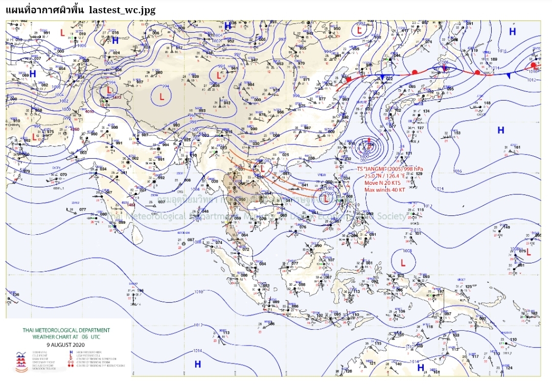
The weather map of March 15th, 2020 shows higher atmospheric pressure and cooler air mass from the far northeast and north which can be seen seeping in and clashing with lower pressure and warmer humid air mass around the upper part of the Gulf of Thailand.

On March 15th, 2020, we could see significant amount of rainfalls measured by rain guage at 'Bang Phra' station of 92.5 mm.

The total amount of rainfalls for March 2020 is quite as high as 117 mm. And it rained four times-days in the month.
----------------------------------------------------------

Doppler weather radar image of April 23rd, 2020 at Sattahip station shows significant weather of squall line started to move into the area.

On April 25th 2020 the Skew-T also shows good sign and levels of humidity.

The weather map of April 23rd and 25th (below), 2020 show higher atmospheric pressure and cooler air masses from the far northeast and north which can be seen seeping in and clashing with lower pressure and warmer humid air masses around the upper part of the Gulf of Thailand and well above into the main land of Thailand.


On April 25th, 2020 we could see significant amount of rainfalls measured by rain guage at 'Bang Phra' station of 32.5 mm.
The total amount of rainfalls for April 2020 is quite as high as 142 mm. And it rained eleven times-days in the month.
------------------------------------------
The amount of rainfalls as recorded for the month of February 2020 is also high with a total of 84 mm. And it rained five times-days in a month.


------------------------------------------
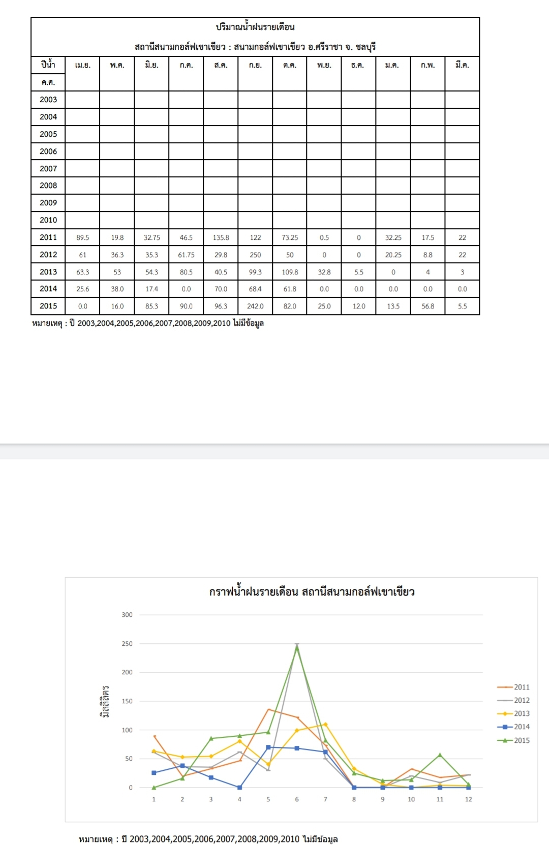
Rainfall statistics for 2011-2015 from another station just to the east near 'Bang Phra'. The left vertical scales are rainfalls amounts in mm. The horizontal scales begin with 1 which is April to 12 as March.
----------------------------------------
Rainfall records for the months of February, March, and April of 2019 respectively which are all much lower.


-----------------------------------------------
An analytical look to these occurrences in estimation and prediction of the charactoristic of annual amount of rainfalls (*non-confirmation*) can perhaps be said that:
It can roughly be seen that the amounts of annual rainfalls in 2014 and 2019 were lower than other years. And this is likely to be at a period of every four higher years where 2010 to 2013 and 2015 to 2018 are higher. Now the 2020 once again shows sign, begins with, of higher amount of rainfalls and may possibly continue in 2021, 2022, and 2023. (This is Only a prediction and not a forecast.)
-----------------------------------------------
And yes, as expected with nature's gesture and sign of implication as per the article written and the info above, a mild condition of La Niña is starting now August 2020. The west Pacific is warmer therefore, it has quite an influence to the Southwest Monsoon wind to blow in stronger bringing along enormous amount of humidity from the Indian Ocean into the South East Asia.


(With thank and appreciation to asmc.asean.org
for the weather data above regarding seasonal forecast and the La Niña 2020.)
----------------------------------------------------
Additional weather data info. of the synoptic weather maps, sattelite pictures, and weather radar images, wind chart:


Lovely southwest monsoon!


-------------------------------------------------------
Have a good year 2020 and altogether always.
Best wishes,
M.L. Chi-ti-tewan Devakul
Comments
Post a Comment